


- L'Alt Berguedà
- How to get there
- Services
- Interest places
- Hiking
- Routes
- Tourism Information Offices
- Towns
- Quality
- Latest news
- Links
-
amb la participació de


From Figols to Peguera - PR-C 73

The historical past of this corner of Berguedà has been marked by coal mining. On this route you will be able to see two characteristic elements of this activity: the remains of various mines and the tracks of dinosaurs. You can round off the route with a visit to the Cercs Mining Museum where you can explore this dark and little-known world in greater detail.
Description
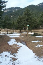
The route starts at the mining community of Sant Corneli, from the car park of the Cercs Mining Museum . You should walk along the road that runs alongside the picnic zone, with its barbecues and tables, following the yellow and white markers of the PR 73. After walking for a kilometre along the asphalt road, leave it and follow a dirt track to the right, which alternates gentle climbs with flat stretches. Having passed by a gunpowder store and a few houses, and having left some crossroads behind, you reach Camanulles, the point you will come back to on your way back from Fígols. You now need to take the left-hand track.
After walking for around fifteen minutes, you should leave the main track and turn off onto another path to the left, with a change of gradient. Immediately afterwards, you will see the remains of some buildings and the mouth of the Curro mine, now abandoned, which shows the mining history of the region.
Following the shadier side of the Fígols path, you come across some very steep sections and other more gentle ones, but always tending to lead upwards. You will pass Morral and the Coll de Sant Ramon before reaching the Coma de Veça, where there is a flat area with three or four pools. The pass is to the right of the second pool. The path on the right is the branch that links this PR with the Fígols turnoff to Torrent del Peu de l'Obaga. You need to follow the left-hand track which climbs gently up to the Coll de la Creu de Fumanya, with some interesting views of the Ensija range and the old open-cast mine of Vallcebre, where dinosaurs' tracks have been discovered. From here, the track starts leading downwards to the Pla de la Creu de Fumanya.
At this point you start the return journey on the old Peguera track which takes you back to Fígols and the end of the route. Towards the left, the path takes you to the village of Peguera and links up with the Camí dels Bons Homes (Route of the Cathars). If you have time, it's worth visiting this abandoned village to enjoy the tranquillity of the valley. It takes around one hour to get there and back. If you do decide to go to Peguera, when you get back to this point you need to cross over the chain and take the right-hand track, which starts leading downhill. Now, we are following the PRC 73-1. Leaving the Creu de Fumanya house on your left, you start going downhill until you come to a stream, which you cross and then follow along its right-hand side. You then come to a point where you find the path that leads directly down to Coma de Veça.
After passing several tracks and paths leading off to the left and right, you come to the asphalt road. You should turn right here and follow the road for around 700 metres to the village of Fígols . In Fígols you will find a church and also a fountain where you can refill your water-bottles before starting off on the last stretch of the route. From here, all you need to do is get to the Camanulles crossroads and retrace the first section of the route back to the starting point.
Route recommended by:

| Distance | 21,5 Km. |
|---|---|
| Route number | 10 |
| Starting point | Sant Corneli. |
| Time | 6 h. |
| Signals | Marques grogues i blanques |
| Car Park | Museu de les Mines de Cercs a Sant Corneli |
| Bibliography | Terra de carbó, guia de la ruta minera. Editorial Zenobita. |
| Ending point | Sant Corneli. |
| maximum altitude | 1652 m. |
| Cartography | Rasos de Peguera – Serra d’Ensija 1:25.000. Editorial Alpina. |
| Comments | El Consorci de Turisme de l'Alt Berguedà no es responsabilitza dels accidents o danys que puguin patir els usuaris durant la realització d' aquesta ruta així com tampoc de les deficiències de senyalització que, ocasionalment, hi puguin haver. |
| Town | Avià |
Documentation attached
Culture
Nature
Center items on the map
Comments

