


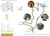
- L'Alt Berguedà
- How to get there
- Services
- Interest places
- Hiking
- Routes
- Tourism Information Offices
- Towns
- Quality
- Latest news
- Links
-
amb la participació de


Two views of Guardiola de Berguedà


Guardiola is a relatively modern village which came into being thanks to the railway. But people have been living in the valley at least since the Middle Ages, as shown by the Monastery of Sant Llorenç prop Bagà. This route combines rugged scenery with extensive views of the Llobregat valley and the gentleness of riverside woodland in a walk that can be done in a morning or afternoon.
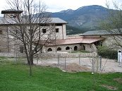
Sant Llorenç prop Bagà
The route starts in front of the Town Hall (Ajuntament). Walking north towards Bagà, take the street to the left that climbs to the Monastery and cemetery. If you want a short cut, you can turn up the Passatge Sant Llorenç and then a path that climbs straight up to join the road near the Monastery. The Monastery is open to the public at certain times, it’s well worth a visit. There is a spring beside the building where you can fill your water bottles.
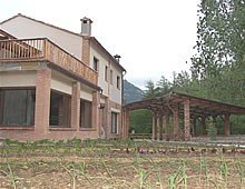
El Vilar
The route passes beside the cemetery and then continues along the track to the house of El Vilar. The name comes from Vila and indicates the presence of dwellers in the Middle Ages. And, indeed, around the house there are some clumps of suspicious looking stones, as well as the overgrown remains of the medieval hamlet at the nearby Coll de Llenes. A path starts from beside the house and enters a copse. To the right, looking up the bank, you will see a hole lined with stones: it’s the spring that the house used to use. The path leaves the wood and the views expand. On the other side of the river, you can see the canal that takes water to the power station near the tunnel of Guardiola. You can even see the aqueduct that crosses the stream of L’Abellol. The tunnel used to be for the railway line, with the old road circling around the hill. On top, there are the remains of the castle of Guardiola, which guarded the meeting point of the routes along the Llobregat and Saldes valleys.
It is a time for enjoying the changing views. Looking from the road below, nobody would think that there could be a path there. We arrive at a pass. If you continue, you will descend to the Saldes river, where you can link up with other waymarked routes. At the pass, you can see the ruins of a stone hut against a rock wall, probably used by charcoal makers who worked in the nearby woods. Our route turns to the left and after following the ridge for a few yards, starts to descend through the woods until it reaches the main road, at the Cases Noves del Collet.
The Llobregat river
After crossing the road using the footbridge, the route goes to the river. Here, even though we are close to the road, everything is peace and calm. A wide path runs along the river bank. In summer, birds and butterflies abound. It is possible to see herons flying or fishing. There are also benches to rest and, half way along, a tap for refilling with water. The enchantment is broken when the path passes under the main road but we’re coming close to the village and in ten minutes’ time, we’ll be back at our starting point.
Route recommended by:

| Distance | 6 Km. |
|---|---|
| Route number | 20 |
| Starting point | Town Hall square, in Guardiola de Berguedà |
| Zone | Guardiola de Berguedà |
| Time | 2 h. |
| Signals | Green-white marks (SL) |
| Bibliography | Catalunya Romànica, volum XII, El Berguedà. |
| Ending point | Town Hall square, Guardiola de Berguedà |
| maximum altitude | 892 m. |
| Cartography | Moixeró- La Tosa 1:25.000. Editorial Alpina. / El Berguedà 1:50.000. Institut Cartogràfic de Catalunya. |
| Comments | El Consorci de Turisme de l'Alt Berguedà no es responsabilitza dels accidents o danys que puguin patir els usuaris durant la realització d' aquesta ruta així com tampoc de les deficiències de senyalització que, ocasionalment, hi puguin haver |

Culture
- Guardiola de Berguedà Railway Station
- Guardiola de Berguedà weekly street market
- Carrilet Verd del Berguedà
- Monastery of Sant Llorenç prop Bagà
- Riutort Petroleum Mine
Nature
Center items on the map
Comments

