


- L'Alt Berguedà
- How to get there
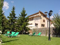
- Services
- Interest places
- Hiking
- Routes
- Tourism Information Offices
- Towns
- Quality
- Latest news
- Links
-
amb la participació de


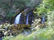
La Dou del Bastareny

Gisclareny is a borough with a scattered population. In the middle of the 19th century, there were some 120 farmhouses scattered throughout the territory, most of them quite impoverished. Hikers at the turn of the 20th century agreed that the village was as a place where misery reigned, with subsistence agriculture - very far from the idyllic environment of today. Even so, they all remarked on the beauty of the Bastareny valley and the houses there. This route runs along some of the paths connecting the houses in the valley, now all abandoned, and the centre of the borough, set in a framework of great natural beauty within the Cadí-Moixeró Natural Park.
Description
The route begins at the Coll de la Bena pass, following the same layout as the Camí dels Bons Homes (Cathars route) (GR 107) and the GR 150. Here you will find Font Vella, a lovely spot and a good opportunity to fill your canteens before starting the walk. Very soon, the GR goes to the right and you should go left until you come to a track that you take and stay on until you reach Murcarols, the first of the great farmhouses of the valley that can be seen along the route. Before getting there, you again come to the waymarks of the GR. The Murcarols house has been documented since the Middle Ages. The present house is in fact the result of several extensions undertaken in different periods. Can you pick out the various additions? (clue: look for the vertical seams that join the walls).
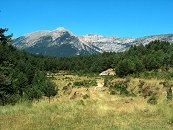
Early documentation also mentioned a castle in this site, perhaps on the shoulder located towards the east. In any case, nothing at all remains of it. Castle or no castle, this is an excellent place to enjoy the view, which stretches from the Bauma pass to the west, Tancalaporta, the Moixa ranges, El Moixeró, and the Cortalets pass below Tancalaporta, the Vimboca coombe in front, and Els Empedrats a little further east. In the northern shady area of the mountain in front, there is an unmistakable depression, wide at the top and narrow at the bottom. This is the Cambra dels Bocs where lambs were closed in after the mating period so as not to bother the ewes and their young.
After the visit, go back to the track junction and take the trail descending to the bottom of the valley. You must be careful on this descent because there are sections with a very steep slope. Along the descent, you will see a house in front. This is Monnell, another of the great farmhouses in the area. It is somewhat far from the route but it can easily be reached by going straight ahead at the track junction when you emerge from the Muga stream. The trail leaves you at the end of the descent after crossing the stream twice. When you cross the stream the second time, the route turns right, but if you follow the path on the left for about a hundred metres, you reach the Murcarols cascade, which is particularly attractive when the flow is heavy. You can see how the rough stone, deposited in times of drought, has gradually taken the form of a toboggan through the action of the water.
When you go back on the route, you reach the Dou del Bastareny, one of the main tourist attractions of the area. Photographs of this cascade appear in countless postcards. At the turn of the 20th century, there was a sawmill here and the logs were carried by cable car to Bagà. If you go down to the stream, before passing the barred track, you will see two cement columns. They held the wheel moved by water carried from the river along a wooden canal. At the other side of the bridge, a path has been laid leading to the spring, some 100 metres upstream from the cascade. This spot is a little wild and quite impressive when the flow is heavy.
You will later come to the Bullidor de Sant Esteve whirlpool. You will see a post indicating the whirlpool on the left side. It leads to some springs at the lower part of the river. They are more easily seen when the water flow is low. Be careful when you go downhill as there are some very high steps.
Go back on to the signposted route and, just before the route veers from the track, you will see a shed on the right from where you will hear the sound of water. This is the Violí spring, the water of which is now carried to Bagà. Before climbing up to El Puig along the trail going right, it's well worth keeping on the track a little further until you reach the Puig or Forat mill next to the river. It is hard to believe that just fifty years ago, all these houses were inhabited and the lands tilled.
The path emerges in front of the Puig house. This house has been cited in documents from the Middle Ages, although the present building dates from the 18th century. It is special in that it is one of the very few houses in El Berguedà to have a hipped roof. The small Romanesque church of Sant Martí del Puig stands above. The door is always open: go in. Behind the church there is a stone with an imprint that looks like a foot. It is called the Virgin's footprint, Petjada de la Mare de Déu.
The path goes up to the ridge to the Escriga pass. It eventually leads to meadows and the view changes. You are now overlooking the neighbourhood of Berta and behind are the majestic peaks of El Pedraforca. When you cross the meadow, you will see piles of stones scattered all around. This is not by chance, they have been heaped up year after year to keep the fields clear. When you see piles of stones like this, it's a sure sign that there were once crop fields there. On the right of the meadow, half hidden by the woods, is the Escriga house and just before going downhill, behind the signposts, are the ruins of Cal Peret, crushed by huge rocks that came off the limestone rockwall against which it was set. Take care on the descent as there are many loose stones in the middle of the path and it is easy to fall.
After descending some 100 metres, the path forks. The sign-posted route continues on the left but if you follow the path going straight ahead, you will go around a rock and see an enormous cavity: this is Cal Bisbe, once inhabited. You can still see some of the stones of the walls and signs of smoke on the rockwalls. It was abandoned in the second half of the 19th century, and now serves as a shelter for goats.
Once at Gisclareny, you will find the spring of the same name; an opportunity to fill your canteens again before reaching the Coll de la Bena pass.
Route recommended by:

| Distance | 11 Km. |
|---|---|
| Route number | 6 |
| Starting point | Coll de la Bena - 1.450 m. (Gisclareny). La ruta també es pot començar des del poble de Gisclareny o des de Cal Cerdanyola (inici de la ruta dels Empedrats). |
| Zone | Gisclareny |
| Time | 11 Km. |
| Signals | Marques verdes i blanques en tota la ruta |
| Car Park | Coll de la Bena. |
| Bibliography | Catalunya Romànica, volum XII, El Berguedà. / Les tres-centes cases de Gisclareny de Francesc Caballé. |
| Ending point | Coll de la Bena - 1.450 m. (Gisclareny) |
| maximum altitude | 1439 m. |
| Cartography | El Berguedà 1:50.000 de l'institut cartogràfic de Catalunya / Moixeró – La Tosa 1:25.000 de l'Editorial Alpina. |
| Comments | El Consorci de Turisme de l'Alt Berguedà no es responsabilitza dels accidents o danys que puguin patir els usuaris durant la realització d' aquesta ruta així com tampoc de les deficiències de senyalització que, ocasionalment, hi puguin haver. |

Documentation attached
Nature
Comments

